Wednesday, January 16, 2019

Malta Day 5 - Victoria Lines


The weather on our last full day was very windy with occasional showers, but we decided to brave the elements and walk a section of the Victoria Lines - a British built fortification system that crosses Malta. We drove to a technical school close to Fort Mosta and Rani found a custodian who showed us how to access the remains of the fortified wall through the school property. Normally the walls could be accessed through public gardens, but these were closed for renovations.

We walked several kilometers of the wall toward the west after first heading east to the edge of the Fort (now closed to the public because it is used for ammunition storage). The wall walk is a bit rough in places and nicely paved in others. People have built their houses into the wall requiring detours to avoid dogs and private property signs. We found the most interesting part of the walk to be at the Bingemma Gap (this also seems to be the most photographed part of the wall). Here we saw a chapel dating from 1670 and catacombs (small interconnected caves in the limestone rock) that are most likely 1500 years old.

Typical tourist information sign - note the walled town of Mdina in the distance

Rani walking a section of the wall - we are outside the moat here and had to walk for a couple of kilometers before we were able to climb the wall and get on the right side of things again

A stone structure viewed from the wall - near the Bingemma Gap

Fields provide a foreground for Rabat and Mdina

Panorama looking northwest from the all near Bingemma

More useful tourist signage - to be fair we did find one sign that had some barely legible text on it still but most signage is in this state

Limestone quarry - the quarrying work was done to less than a meter from the road we were walking on with a 100 foot hole immediately beside the road and the historic wall a few meters away,

View West showing the Victoria Lines in the distance

Not sure what these structures or wall workings are here at the Bingemma Gap

Loop holes

Much photographed section of the wall at Bingemma is the most impressive part that we walked - below and to the right and left are catacombs carved into the rock

Hiding from the wind, we had lunch in this shelter that was presumably once higher walled and roofed.

Catacombs and wall


Another catacomb - chambers are interconnected and each would have contained one or more burials

The opening would have been closed originally and probably plastered over - vandals likely robbed these many hundreds of years ago

We ran into these sheep and goats within the fortifications near Bingemma


Malta Day 4 - Mdina and Rabat

Today we set out to walk along a portion of the Victoria Lines, a fortified wall that follows a fault line across the island of Malta. Rain and high winds drove us from this goal and instead we visited the walled town of Mdina and its neighbor, Rabat. Mdina was once the capitol of Malta and a place of great religious significance. It is surrounded by impressive walls and consists of a warren of high walled streets, churches, residences, museums, and a few restaurants and stores.

We walked most of the streets and visited the excellent Cathedral and related museum.

Mdina from a nearby road - showing the dome of the cathedral

Main gate - detail. Horse drawn carriage rides are available and cars are allowed in Mdina, although only on some streets

Gate detail


About half the streets are this narrow and suitable for pedestrians or horses only

Cathedral dome
The main square has some lovely buildings

Architectural detail

The museum admission is 5 euros and well worth it. The collection of silver religious artifacts is impressive and the museum building itself is stunning.

Silver hanging lamp detail - lamps like this were in use in the cathedral

Silver filigree monstrance for the display of objects of piety. Filigree worked jewelry is a common tourist item still

Reliquary containing saintly bones

A book reliquary - yet another way to house bones

Detail of a large reliquary containing a skull

The museum had a collection of teapots and related vessels with butterfly adornments


This fellow reminded me of our friend Kurt with whom we will soon be sailing

Saint Agatha appears a bit annoyed in this painting - for obvious reasons. Agatha is the patron saint of Malta and also (according to Wikipedia) ...of breast cancer patients, martyrs, wet nurses, bell-founders, bakers, fire, earthquakes, and eruptions of Mount Etna

The museum floors were inlaid with beautiful marbles
Colourful inlaid grave marker in the cathedral floor

The cathedral was decorated in scarlet cloth for Christmas

Altar displaying the apostles in silver with baby Jesus

It is not possible to do justice with a photo to the impressive dome and its wonderful paintings

Neighbouring Rabat is similar to Mdina in its narrow streets and architecture - but is a lively and vibrant place in comparison to the frozen museum quality of  its neighbour


Wednesday, January 9, 2019

Malta Day 3 - Up North

Given how much fun it has been driving in the urban areas of Malta, we thought we would head north away from the population centers of Saint Julians and Valleta. The only major center along the route is Saint Paul's Bay and we mostly managed to bypass this.

We had read about a hike along the most northern peninsula on the main island called Marfa Ridge, so armed with a trail map on our cell phone we drove to Ghadira  (pronounced A-deer-a) Bay. Just short of the trail head we stopped at a resort supermarket to buy bread, cheese and fruit for a picnic lunch. The cashiers were very friendly and we discussed the complex roots of the Maltese language - Arabic, English, French, Italian, etc - a product of the many invasions that have shaped Malta.

Our rental Picanto

It would probably have been a good idea to review the hiking notes before beginning this hike, but we hadn't, and soon realised that we were starting at the trail end. As in yesterday's walk, we ended up off the described route and for a few hours the only people we encountered were one group of local hikers and a Maltese/Canadian named Joe working on his land holding. We found ourselves on a path used by the farmers to access their fields of crops (which are limited here due to the arid conditions and poor soil). These common paths wind their way between hundreds of private land holdings and may continue for miles. As we walked further on this path, we came to wilder, more rugged terrain where some scrambling was required.

Path between furrowed farmers' fields

Limestone shelves and giant boulders 

Little Rani, Big Boulder

A patch of eroded clay that reminded us of the hoodoos in the Canadian or US west

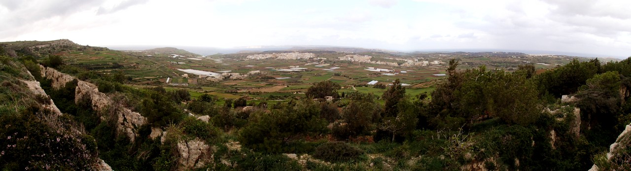
The views of the west coast from the limestone cliffs were superb. There were fossils embedded in the ledges and shelves we crossed and a sea breeze kept us cool throughout. In the summer, we would have been tempted to bathe in the secluded inlets, but getting in and out of the ocean would have been exciting because the limestone is very rough. There were large patches of yellow wildflowers, a few palm trees and even a tiny forest of bamboo in clay soil.

Coastal panorama

Fossilized sand dollar

Golden flowers - maybe creeping wood sorrel?
We stopped briefly at St. Agatha's Tower, a red ochre watchtower built in 1657, one of a chain of such towers on the north and east coasts used by the Knights of Malta during the 17th and 18th centuries. It overlooks the potential enemy landing sites at Mellielha Bay and has a commanding view of the islands of Comino and Gozo. Unfortunately, like many of the tourist sites in Malta, it was closed to visitors!

St. Agatha's Tower 

Along the trail we came across beehive shaped corbelled huts, called girna, that are constructed from loose rocks and stones gathered from the local garrue (scrub land). These and their more common rectangular cousins, roofed with wood or panels, may look primitive, but they are very sturdy and provide shelter for the farmers from the elements. Some are also grouped together to shelter animals.

Rani looking towards Gozo  (note the corbelled hut behind me)


A crude rock hut shelter. If you look closely you will see that the photographer accidentally made Rani's legs turn to stone! 

The Maltese islands used to be covered in trees but when man arrived 7000 years ago, the forests were cleared for farming and the wood used for fires, leaving very few patches of forest. There is an effort to regrow trees in some areas by non-profit organizations such as BirdLife Malta, and we passed through several conservation areas on our hike. We saw replantings of Aleppo pines among the ubiquitous olive trees. Hopefully these will attract more birds.

We decided to forego the opportunity to visit the reverse osmosis plant and ferry terminal, and drove instead to the end of the road for a walk along the cliffs above Slugs Cove. Signs of erosion and a memorial here kept us (mostly) at a safe distance from the edge.

View towards Gozo island
Posted by Rani...